Project
Community
News
My App
My maps
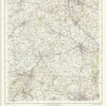
Part of Staffordshire Containing 100 Square Miles Surveyed by Mr Field and Drawn by Mr Stevens 1817
1817
Stafford (Hills) - OS One-Inch Revised New Series
1898
Ordnance Survey
1:63k
Stafford (Outline) - OS One-Inch Revised New Series
1898
Ordnance Survey
1:63k
139 Stafford (Hills)
1899
Ordnance Survey Office
1:63k
139 Stafford (Outline)
1899
Ordnance Survey Office
1:63k
Chartley Park
1832
Stafford - OS One-Inch Map
1949
Ordnance Survey
1:63k
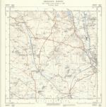
SJ83 - OS 1:25,000 Provisional Series Map
1937
Ordnance Survey
1:25k
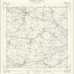
SJ82 - OS 1:25,000 Provisional Series Map
1938
Ordnance Survey
1:25k
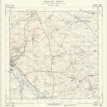
SJ93 - OS 1:25,000 Provisional Series Map
1938
Ordnance Survey
1:25k
History
Old maps of Stafford Township, New Jersey
Discover the past of Stafford Township, New Jersey on historical maps
Old maps of Stafford Township, New Jersey
Discover the past of Stafford Township, New Jersey on historical maps
Explore Maps
Discover History
Parent places
Ocean County, New Jersey
Related places